
High winds, heavy rain, and possible tornadoes prompted alerts across central Indiana as storms moved through overnight.
Powerful storms moved across Indiana on April 27, bringing the threat of damaging winds, flash flooding, and isolated tornadoes, as forecasters warned conditions could remain hazardous into the early hours of April 28.
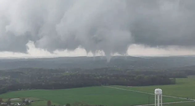
The National Weather Service in Indianapolis said severe thunderstorms were expected to intensify through the evening, with wind gusts reaching up to 60 miles per hour. Meteorologists also warned of potential tornado activity, hail, and localized flooding as the storm system advanced.
By late evening, conditions had worsened enough to prompt tornado warnings in several areas. Alerts were issued for southern Marion County and northern Johnson County, later extended to include southeastern Marion County, northeastern Johnson County, and parts of Hancock County. A separate warning was also announced for Monroe County as storm cells strengthened.
Earlier in the night, forecasters had tracked a line of storms developing to the west, stretching across Illinois and moving toward central Indiana. According to meteorologist Chad Swain, these storms were expected to be the most intense of the evening, arriving before midnight and continuing into the early morning hours.
The severe weather quickly began to disrupt daily activity. At Indianapolis International Airport, dozens of flights were delayed or canceled as conditions deteriorated. By mid-evening, at least a dozen flights had been canceled, with more than 90 experiencing delays. Earlier in the afternoon, delays had steadily increased as the storm system approached.
On the ground, widespread power outages affected thousands of residents. At one point, more than 7,400 customers were without electricity, primarily on the south side of Indianapolis and in nearby communities. Utility officials later reported improvement, with outages dropping to around 1,700 customers as crews worked to restore service.
Forecasters had warned hours earlier that repeated rounds of heavy rainfall could lead to flash flooding. A flood watch remained in effect for much of central and southern Indiana through at least 2 a.m., as storms moved over the same areas multiple times.
“There is a line of storms stretching across Illinois,” meteorologist Chad Swain said earlier in the evening, noting that the system was expected to bring the strongest impacts before midnight.
As the storm system continued to move through the region overnight, officials urged residents to remain alert and monitor weather updates. With the threat of severe conditions lingering into the early morning, emergency preparedness remained critical across affected areas.
This storm system is a reminder of how quickly conditions can escalate during severe weather season in the Midwest. While forecasts provided advance warning, the scale of disruption—from travel delays to power outages—shows the importance of preparedness. As weather patterns grow more unpredictable, timely communication becomes even more essential.
#IndianaWeather, #SevereStorms, #TornadoWarning, #Indianapolis, #MidwestWeather, #StormAlert, #WeatherNews, #FlashFlood, #PowerOutage, #FlightDelays